The Laugavegur Trail is a 55-kilometre camping trek with four main overnight stops
- Total length: about 55 km, usually shown as 34 miles as well.
- Common pacing: four days and four nights is the standard way to walk it.
- Main stages: 12 km, 12 km, 16 km, and 15 km.
- Camping: tents are allowed by all of the main huts, but bookings are expected in advance.
- Conditions: at least three rivers need to be waded, and weather can change fast.
- Best season: usually late June to mid-September, depending on snow and road openings.
The official length and why the number varies a little
The cleanest answer is that the Laugavegur Trail is about 55 kilometres from Landmannalaugar to Þórsmörk. You will also see it rounded to 54 kilometres in some guides and booking pages, which is normal on a route like this because small measuring differences and slight route variants change the final figure a little. For most hikers, that difference is not important; the trail is still a proper multi-day highland traverse, not a casual weekend walk.
I think the mileage matters less here than the terrain. Fifty-five kilometres on a smooth path is one thing. Fifty-five kilometres across volcanic ground, exposed ridges, river crossings, and changing weather is something else entirely. That is why the next question is never just “how far is it?”, but “how should I break it up?”
How the trail is usually split across four days
The classic way to hike the route is in four stages, and that pacing is the most practical answer for most people. The official stage lengths line up neatly with the full distance, and they also match the way most hut and camping bookings are organised. In other words, the trail is designed around overnight stops rather than one long push.
| Stage | Distance | Typical time | Overnight stop | What it feels like |
|---|---|---|---|---|
| Landmannalaugar to Hrafntinnusker | 12 km | 4-5 hours | Hrafntinnusker | Shortest day on paper, but steep and exposed, with snow possible early in the season. |
| Hrafntinnusker to Álftavatn | 12 km | 4-5 hours | Álftavatn | A big scenery change, more descending, and a better introduction to the trail rhythm. |
| Álftavatn to Botnar/Emstrur | 16 km | 6-7 hours | Emstrur | The longest full day for many hikers, with wades, wide views, and a more remote feel. |
| Botnar/Emstrur to Þórsmörk | 15 km | 6-7 hours | Þórsmörk | A long finish with canyons, looser ground in places, and the reward of reaching sheltered woodland. |
There is some flexibility in how people book the route, and I like that because it gives stronger hikers a faster option and slower walkers more breathing room. Still, if I were planning this from scratch, I would treat four days as the default and anything shorter as a more serious undertaking. That leads straight into the camping side of the trail, which is where the practical decisions really start to matter.
Where you can camp or stay beside the trail
Camping is possible by all of the main huts on the Laugavegur Trail, but that does not mean you can arrive casually and sort things out on the day. The official trail pages expect confirmed bookings for huts or campsites before you start, and that is sensible because these places sell out quickly in peak season. If you are travelling from the UK, I would book this as soon as your dates are fixed, not when your flight is already close.
The overnight stops are part of the appeal, and each one has a different character:
- Hrafntinnusker is the most exposed and the most weather-sensitive campsite on the route. It can be dramatic, but it is not a gentle first night if the weather turns cold or snowy.
- Álftavatn sits about halfway along the trail and feels like the point where the route settles into its rhythm. It is a good, balanced stop for most walkers.
- Emstrur is set in a more austere highland landscape, with the campsite lower down below the huts. It works well as the “middle of nowhere” night.
- Þórsmörk is the most sheltered and comfortable finish, with a greener, more wooded feel that usually feels like a release after the open highlands.
There is also a difference between what campers and hut guests can use. Campers can access bathrooms, drinking water, and outdoor tables and benches, but they cannot use the hut kitchens or other indoor facilities. In practice, that means you should arrive fully equipped, especially with a tent that can handle wind and ground that is not always friendly to pegs. The campsites are excellent, but they are still part of a remote highland route, not a serviced holiday park.
Once you understand the overnight pattern, the next question is why such a relatively short trail still asks so much of people.
Why 55 kilometres feels like a bigger challenge
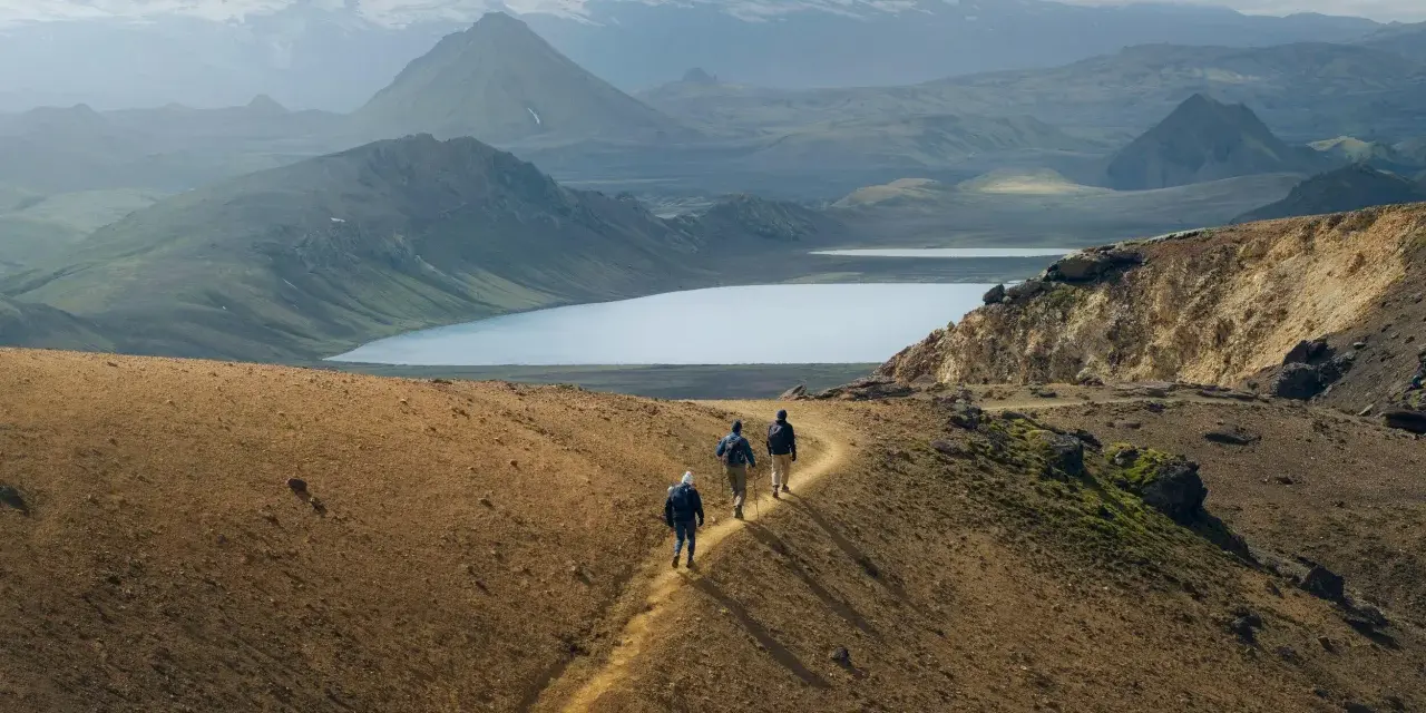
Distance alone does not explain the Laugavegur Trail. The reason it feels harder than the mileage suggests is that the route keeps asking for attention. There are steep early climbs, long sections of exposed terrain, at least three river crossings that have to be waded, and weather that can swing from clear to foggy or windy in a short time. That mix slows almost everyone down.
A few factors make the trail feel more serious than a flat 55-kilometre walk:
- Elevation and exposure: the first day climbs quickly, and high sections can hold snow well into the season.
- River crossings: some crossings are bridged, but at least three still require wading, so timing and confidence matter.
- Loose ground: volcanic gravel, black sand, and steep slopes make progress slower than the map might suggest.
- Weather volatility: fog, wind, and rain can all change pacing, navigation, and comfort.
- Pack weight: if you are camping, every extra kilo is felt by the end of day two.
There is also a connectivity reality that catches some first-timers off guard: phone signal can be unstable, and Wi-Fi is not available in the huts. That is not a problem if you plan for it, but it is a problem if you expect the trail to behave like a normal tourist route. From here, the best advice is not about fitness alone, but about planning the logistics properly.
How I would plan the trip from the UK
If I were organising this from the UK, I would treat the trail as a summer expedition rather than a standard camping break. The usual hiking window is roughly late June to mid-September, but that window is still shaped by snow, road openings, and local conditions, so I would never assume the route is ready just because the calendar says summer. Booking early matters more here than on most trails because the camps and huts are limited and demand is high.
I would also choose the pacing before anything else. The booking structure reflects the real options: there are 3-night, 4-night, and 5-night arrangements, and the right one depends on how comfortable you are with long days and changing weather. My default choice would be four nights. Three is doable for strong walkers, but it leaves less margin for bad weather or slow river crossings. Five is kinder if you want to move steadily and enjoy the landscape without rushing.
For kit, I would keep it simple and reliable:
- A tent that copes well with wind.
- Good pegs and guylines, not just a light shelter.
- Fast-drying layers and a proper waterproof shell.
- Food for the full route, plus a little extra.
- Gas and cooking gear if you are camping rather than using huts.
The huts along the trail do sell some supplies, including basic backpacking food, drinks, and fuel, but I would not rely on that as my main plan. The smart approach is to arrive self-sufficient and treat any extra purchase as a bonus. That mindset keeps the route enjoyable instead of turning it into a resupply problem.
The practical takeaway before you commit
The shortest honest answer is this: the Laugavegur Trail is about 55 kilometres long, usually walked in four days, and best understood as a camping route with serious mountain conditions rather than a simple point-to-point path. If you are deciding whether it belongs on your list, I would focus less on the mileage and more on the booking calendar, the season, and how comfortable you are with exposed terrain and river crossings.
For me, the trail becomes most attractive when those three things line up: a stable weather window, a confirmed campsite plan, and a pack that is light enough to move well but complete enough to keep you safe. Get those right, and the distance stops being the main issue. The route then becomes what it is known for: a compact, unforgettable highland trek with some of Iceland’s best camping stops built into the journey.