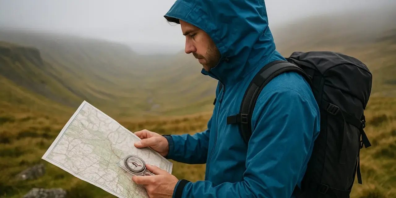
I treat a compass as a route-control tool, not a museum piece. On UK hikes, it is what keeps a line honest when the path vanishes into heather, the mist drops, or every slope starts looking the same.
Learning how to use a compass is really about connecting three things: the map, the landscape, and the next safe point you want to reach. In this guide I’ll cover the parts that matter, the norths on an OS map, how to take and follow a bearing, and the mistakes that trip up even careful walkers.
The essentials for staying on route in the hills
- A compass only becomes useful when you pair it with a map and a clear destination.
- In Great Britain, the correction between map north and compass north is small but important.
- Hold the compass flat, keep it away from metal and electronics, and re-check it often.
- Walk in short legs by picking a feature ahead, not by staring at the dial the whole time.
- Use the compass to stay oriented, but still read contours, handrails, and catch features.
Why a compass still earns space in your pack
Even when I carry a phone, I still want a proper compass in the pack. Batteries hate cold, screens hate rain, and both become less reassuring when you are tired, wet, or trying to make sense of a featureless hillside.
For hiking and backpacking, the compass does one job extremely well: it turns a map into a direction you can follow. That matters on moorland, in forest blocks, on ridgelines in cloud, and anywhere the path becomes faint enough that you would rather trust a bearing than a guess. It also helps with route planning before you set off, because a backpacking day often works better when I have already marked the main bearings and escape lines on the map.
The point is not to replace judgement. It is to keep your judgement anchored when visibility, fatigue, or terrain starts working against you. Once that is clear, the next step is knowing which parts of the compass actually matter in the field.
Know the parts that actually affect direction
A hill compass can look more complicated than it really is. For normal navigation, I focus on the pieces that help me line up the map, set a bearing, and follow it without second-guessing myself.
| Part | What it does | Why I care on a walk |
|---|---|---|
| Baseplate | Clear flat body that sits on the map | Lets me line up a route without hiding the map underneath |
| Rotating bezel | Numbered dial from 0 to 360 degrees | Used to set the bearing I want to walk |
| Orienting arrow and lines | Marks inside the capsule that match map grid lines | Help me align the compass with north on the map |
| Direction of travel arrow | Arrow pointing where I should walk | Shows the line I should follow once the bearing is set |
| Magnetic needle | Red end settles toward magnetic north | Lets me orient myself in the landscape |
| Index line | Fixed reading point on the bezel | Tells me the exact bearing I have set |
For hiking and backpacking, a simple baseplate compass is usually enough. A mirror compass can be handy for more precise sighting, but I would not let that distract from the basics: a clear dial, a stable needle, and readable orienting lines. Once those are familiar, the real issue becomes north itself, because that is where many beginners lose time and confidence.
Read the norths correctly on an OS map
On UK hill days, this is the bit I slow down for. Ordnance Survey maps use grid north, your compass points to magnetic north, and true north is the geographic reference in the background. Those are not the same thing, and the small difference between them is what makes a bearing accurate or sloppy.
I do not guess that correction from memory. I check the north diagram or legend on the map, because the grid-magnetic angle changes by location and over time. In Great Britain it is often only a few degrees, but that is enough to send you noticeably off line over distance, especially on a long crossing or in poor visibility. If I am using an older paper map or a photocopy, I assume the printed correction may be out of date and I verify it before I rely on it.
| North type | What it means | Practical effect |
|---|---|---|
| True north | The direction of the geographic North Pole | Useful as a reference, but not what the compass needle follows |
| Grid north | The north direction shown by the vertical grid lines on an OS map | What I work with when I plot a line on the map |
| Magnetic north | The direction the compass needle points | What I must match when I step off the map and into the landscape |
| Grid-magnetic angle | The correction between map north and compass north | Needed every time I convert a map line into a walking bearing |
Once those three norths make sense, setting a bearing stops feeling mysterious. The actual process is simple, and that is a good thing, because simple skills are the ones you can repeat under pressure.
Set a bearing from the map
The cleanest way I know is to work from map to ground in one straight sequence. I keep the map flat, line up the route, and let the compass do the measuring rather than trying to eyeball the direction.
- Put the map on a flat surface and mark your current position and destination.
- Lay the long edge of the compass between those two points, with the direction of travel arrow pointing toward the destination.
- Rotate the bezel until the orienting lines sit parallel with the north-south grid lines on the map.
- Read the bearing at the index line and apply the correction shown on the map’s north diagram.
- Take the compass off the map and hold it flat at waist height.
If the feature you want is broad rather than exact, I prefer to aim for a sensible attack point instead of chasing a tiny detail. For example, I will often take a bearing to a ridge corner, stream junction, or saddle, then use the terrain to finish the last part of the approach. That is usually safer and less fiddly than trying to hit a summit cairn from a kilometre away.
One detail that helps a lot: if you need to convert a map line into a walking line, do it before you start moving. Fumbling with the dial while you are already walking is how people drift, overshoot, or convince themselves the compass is wrong when it is usually the setup that was sloppy. From there, the real skill is walking the bearing without wandering.
Walk the bearing without drifting off line
Once the bearing is set, I turn my body until the red needle sits inside the orienting arrow, keep the compass level, and let the direction of travel arrow point the way. That position tells me I am facing the line I want, but it does not mean I should march blindly for twenty minutes.
What works better is a chain of short corrections. I pick a feature in the distance that sits on the bearing, walk to it, check again, and repeat. On open moorland or in mist, that might mean only 30 to 60 metres at a time. In clearer country, I can stretch that out, but I still prefer to re-sight regularly rather than assume I am holding a perfect line.
I also use land features as checkpoints. A stream, wall, ridge, gully, path junction, or change in slope can confirm whether the bearing makes sense. A compass tells me direction; the terrain tells me whether that direction still fits the map. That partnership is what makes the method reliable instead of mechanical.
The mistakes that usually throw people off route
Most compass errors are boring, not dramatic. That is good news, because boring errors are easy to fix once you know what to look for. Here are the ones I see most often on hills and backpacking routes.
| Mistake | What it causes | How I fix it |
|---|---|---|
| Holding the compass at an angle | The needle sticks or swings badly | Keep it flat and level at waist height |
| Leaving a phone, knife, or buckle too close | The needle gives a false reading | Move away from metal and electronics before I trust the dial |
| Forgetting the map correction | The route slowly drifts off the intended line | Read the north diagram on the map before I step off |
| Reading the wrong end of the needle | I may walk the exact opposite direction | Check that the red end is inside the orienting arrow |
| Marching without checking the ground | I arrive in the wrong place even with a good bearing | Use contour lines, handrails, and catch features as backup |
The last mistake is the most common one on real routes: trusting the compass so much that the map gets ignored. I would rather stop for ten seconds and confirm a contour, a fence line, or a stream bend than spend ten minutes trying to recover from a quiet error. That habit matters even more when the weather turns, because the compass is a navigation tool, not a safety certificate.
When the compass is not enough on its own
A compass will not tell you whether a slope is safe, whether a stream is passable, or whether the ground under your feet is changing from firm grass to a bog. It only tells you direction. That is why I treat it as part of a wider decision-making process rather than as the final answer.
If visibility is poor, I slow the whole process down. I stop at a known point, orient the map, confirm my last certain location, and then take a fresh bearing to the next sensible feature. If things still feel uncertain, I would rather retreat to the last safe point than keep pushing a line I cannot justify. For backpacking, that can mean building in escape bearings before the day starts so the fallback route is already clear.
Electronics can help, but I never let them replace the basic discipline of map, compass, and terrain. When a battery fails or a screen gets useless in rain, the simple method still works because it does not depend on signal or power. That is why the best compass users are usually not the fastest; they are the ones who stay calm and keep the process tidy.
The routine I trust on real UK hill days
On an actual hike, I keep the whole process modest and repeatable. Before setting off, I check the north diagram, identify the main features on the route, and write down the bearings for any exposed sections or escape lines. That takes a few minutes and pays for itself the first time the weather closes in.
- I check the map at every major decision point, not only when I feel lost.
- I use short legs between obvious terrain features instead of long blind marches.
- I keep the compass away from phones and other metal until the reading is done.
- I stop and reorient the map whenever the terrain stops matching my expectation.
- On family walks, I turn the checks into a simple habit so everyone knows where we are heading next.
If I had to reduce the whole skill to one habit, it would be this: set the bearing carefully, walk it in short sections, and keep comparing the line on the map with the ground in front of you. That is what makes compass navigation dependable on UK hills, whether I am out for a short moorland walk or carrying a pack for several days.